McLennan County
ARES Application
NOTE: Don’t complete the form in your browser.
1) Download/Save this form.
2) Open w/ pdf viewer, fill, and save.
3) Send as instructed on form.
HOTARC members stand ready to serve the community with our communications skills, equipment, and license privileges—whether it be for special events, education, stormy weather, or other emergency conditions.
For example, when severe weather threatens central Texas, at the direction of the Fort Worth office of the National Weather Service, HOTARC ARES members mobilize as the
Baker’s Dozen Weather Net
Weekly Training Net convenes every Monday at 8:00 PM on 145.15 MHz (–600 kHz, PL 123 Hz). Click here for the weekly Net Control Schedule.
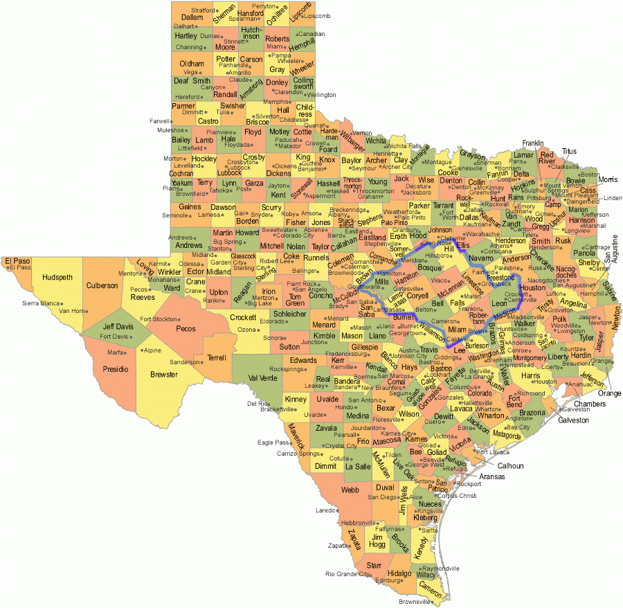
The BDWN communicates from thirteen counties in central Texas, as shown below:
Click here to sign up for automatic NWS notifications of central Texas severe weather and storm spotter activations.
BDWN Counties (north to south)
- Bosque (Meridian)
- Hill (Hillsboro)
- Hamilton (Hamilton)
- McLennan (Waco)
- Limestone (Groesbeck)
- Mills (Goldthwaite)
- Coryell (Gatesville)
- Falls (Marlin)
- Leon (Centerville)
- Lampasas (Lampasas)
- Bell (Belton)
- Robertson (Franklin)
- Milam (Cameron)

(Hover your mouse over a county to see it’s name.)
The FCC expects amateur radio operators to use their skills and equipment to help their community in emergency situations. One of the best ways to prepare for this is to register and practice with the Amateur Radio Emergency Service (ARES). With the rising number and severity of national-scale disasters, the need for adequate preparation and identification of amateur radio operators has risen dramatically. It is now imperative for those wanting to really contribute to service and have access to restricted emergency sites to register with their local ARES organization, and complete required training courses (see below). We fully expect the next large disaster to call upon amateur radio operators more than ever before. However, to help at a disaster scene now, you must have proper identification and training. To this end, it is imperative that you complete and submit an ARES Application
—before the emergency comes!
All Texas counties
(click image for larger map)
The Texas Department of Transportation (TxDOT) provides detailed maps of the state’s county road system. These maps can be very helpful during BDWN storm spotting, providing road details and names often omitted by online road maps. You can freely view, print, or save the PDF files (to your smartphone, tablet, etc.) by visiting the TxDOT web site to access maps of ALL Texas counties.
The image here includes quick links to the map pages for McLennan County. (Click on a grid square numbered in the image.)
 Click a grid square above for PDF map from TX-DOT Maps.
Online Training
As part of your ARES membership, it is strongly recommended (required to support an actual emergency) that all ARES members complete the following four free online courses from FEMA:
- IS-700.B (NIMS) – Introduction to the National Incident Management System
- IS-100.C (ICS) – Introduction to the Incident Command System
- IS-200.C (ICS) – Basic Incident Command System for Initial Response
- IS-800.C (NRF) – Introduction to National Response Framework
and highly recommended:
- IS-271.A – Anticipating Hazardous Weather & Community Risk
- ARRL Courses and Training (e.g., EC-001, EC-002, and EC-003)
For drills, exercises, and actual emergencies activities, proof of completion of one or more of these courses will be required. Your ARES identification card can provide that.

Check in to the weekly training nets and ARES activations (e.g., storm spotting or other emergency situation). The central Texas ARES training net currently meets every Monday at 8:00 PM on the HOTARC 145.15 MHz repeater.
Upon registering with ARES, a list of local repeaters will be provided to you. Program your radio(s) with these area repeater parameters, and know how to access them. During an emergency is not the time to be learning how to use your radio’s features and functions!
For more information, contact KG5DHS Paul Collins, ARES McLennan County Emergency Coordinator.

Other Links
- U.S. Lightning Maps: Vaisala (2 hours) Intellicast (1 hour)
- National Weather Service (Dallas-Fort Worth Office)
- Storm Spotters Checklist : Skywarn hanndout
- Local SKYWARN Frequencies Map: Ham repeater frequencies for emergencies.
- NOAA Tornado FAQ: Excellent digest of latest info
- Weekly HOTARC-ARES Net Control Schedule
- Difference between RACES and ARES (ARRL web site)
- Stormpulse: Hurricane, severe weather tracking, etc.
- HOTREADY: Register for central Texas automatic emergency notifications
- SATERN (Salvation Army Team Emergency Radio Network): Membership Application